
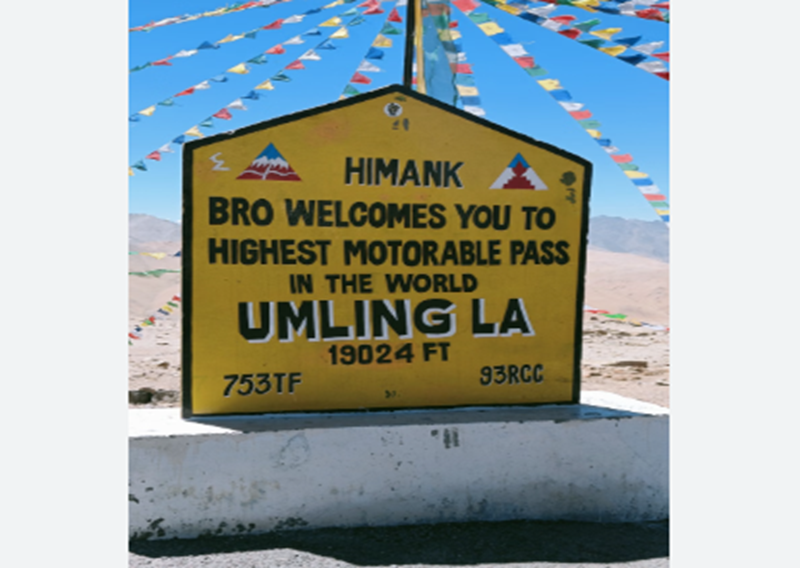
Umling La Pass (also known as Umlung La) is a high-altitude mountain pass in the remote Changthang region of eastern Ladakh, India. It is renowned for its extreme elevation, strategic location near the India-China border, and the remarkable engineering feat of the motorable road that crosses it.
Umling La Pass Location
Umling La lies in the Changthang Plateau of the Union Territory of Ladakh, near the village of Demchok and close to the Line of Actual Control (LAC) with China. It sits on the ridgeline that separates the Koyul Lungpa valley from the Indus River basin. The pass forms the source of the Umlung stream (which drains into the Indus) and a tributary of the Kiungdul river (draining into Koyul Lungpa). Approximate coordinates are 32°41′35″N 79°16′17″E. It is part of the high Himalayan landscape in a sparsely populated, arid high-altitude desert region.
Umling La Pass Height (Altitude)
The pass stands at about 5,799 metres (19,024 feet) above sea level. Some Border Roads Organisation (BRO) references note road sections approaching nearly 19,300 feet during construction. This elevation places it higher than the South Base Camp of Mount Everest (around 17,598 feet / 5,364 m) and significantly above earlier famous Ladakh passes such as Khardung La (officially about 17,582 feet). Oxygen levels at the pass are roughly 50% of those at sea level, making physical exertion extremely demanding and increasing the risk of acute mountain sickness.
Umling La Pass Connectivity and the Road
The Umling La Road (also called the Chisumle–Umling La–Demchok Road or CUD Road) is a paved, motorable road constructed by India’s Border Roads Organisation under Project Himank. Work was completed in 2017 (with public recognition and further surfacing in subsequent years), transforming what was previously a difficult mule track into a modern blacktop route.
- It connects the villages of Chisumle (or Chismule/Chisumle) and Demchok.
- The core Chisumle–Umling La–Demchok stretch is roughly 52–54 km long (about 25 km from Chisumle to the pass and a similar distance onward to Demchok). Some references cite broader connectivity of around 86 km between the linked settlements.
- Access from Leh (the main town of Ladakh) typically follows routes such as Leh → Upshi → Chumathang → Mahe → Nyoma → Hanle → Photi La → Umling La. Distance from Leh is approximately 230–350 km depending on the exact route and conditions, taking 8–10 hours or more. Alternative approaches exist via Ukdungle or other tracks. Hanle is a common base, lying roughly 75–88 km from the pass depending on the path taken.
The road remains subject to seasonal closures due to heavy snowfall and is generally accessible from roughly April/May to October, weather permitting. BRO maintains it under challenging high-altitude conditions. Note that access can be influenced by military and border considerations; domestic tourists have generally been able to visit in recent years (with environmental fees in some cases), while foreign tourist access has historically been more restricted.
Umling La Pass Significance
Umling La holds major strategic, engineering, and socio-economic importance:
- Strategic/military: Located near the sensitive Demchok area and the Chumar sector of the LAC, the road enables faster movement of troops, equipment, and logistics in a critical border region. It strengthens India’s infrastructure presence and connectivity in eastern Ladakh.
- Engineering achievement: Building and maintaining a high-quality motorable road at this altitude, in extreme cold and low-oxygen conditions with a short working season, is an extraordinary feat by the BRO. From 2017/2021 until 2025 it held the title of the world’s highest motorable road (surpassing Bolivia’s Uturuncu volcano road at about 18,953 feet). In 2025 it was surpassed by India’s own Mig La road (around 19,400 feet / 5,900+ m).
- Local development and tourism: It provides an alternate, faster link for remote villages, improving access to markets, services, and opportunities. It has boosted adventure tourism, motorcycle expeditions, and interest in the Changthang region’s landscapes, wildlife, and nearby sites such as Hanle (known for its observatory and clear skies).
Umling La Pass Temperature and Climate
Conditions are harsh year-round due to the extreme altitude and continental high-altitude desert climate:
- Winter temperatures can plummet to –40°C (and occasionally lower, with strong wind chill). Heavy snowfall is common.
- Summer daytime temperatures are milder (often in the range of about 5–15°C or occasionally higher in lower sections, up to around 20–25°C in broader eastern Ladakh valleys), but nights remain cold and conditions at the pass itself stay chilly with strong winds.
- The thin air, intense solar radiation, rapid weather changes, and risk of high winds add to the challenges for both construction crews and travellers. Proper acclimatisation, warm layered clothing, and caution regarding altitude sickness are essential.
Umling La stands as a striking example of human determination and infrastructure capability in one of the most extreme environments on Earth. It continues to draw adventure seekers while serving vital strategic and developmental roles in India’s high Himalayan frontier. Always check current road status, weather, and any permit or access requirements before planning a visit, and prioritise safety and acclimatisation.
FAQs Based on Umling La Pass
Q1. Where is Umling La Pass located?
Umling La Pass is located in the Ladakh region of India, near the India-China border. It connects the towns of Chisumle and Demchok and lies in a remote high-altitude area of eastern Ladakh.
Q2. What is the height of Umling La Pass?
Umling La Pass is one of the highest motorable roads in the world, situated at an altitude of approximately 19,024 feet (5,798 meters) above sea level.
Q3. Who constructed the road to Umling La Pass?
The road was constructed by the Border Roads Organisation (BRO) of India under the Project Himank initiative to improve connectivity in strategic border areas.
Q4. Is Umling La Pass higher than Khardung La?
Yes, Umling La Pass is higher than Khardung La. While Khardung La is at about 18,380 feet, Umling La surpasses it, making it the highest motorable road globally.
Q5. Can tourists visit Umling La Pass?
Yes, tourists can visit Umling La Pass, but they need special permits due to its proximity to the international border. The journey is challenging and requires proper planning.
Q6. What permits are required to visit Umling La Pass?
Visitors need an Inner Line Permit (ILP) issued by the Ladakh administration to travel to Umling La and nearby restricted areas.
Q7. What is the best time to visit Umling La Pass?
The best time to visit is between May and September when the weather is relatively stable and roads are accessible. Winters are extremely harsh with heavy snowfall.
Q8. What are the major challenges of traveling to Umling La Pass?
Travelers face extreme altitude, low oxygen levels, unpredictable weather, and rough terrain. Proper acclimatization is essential to avoid altitude sickness.
Q9. How can one reach Umling La Pass?
Travelers typically reach Leh first by air or road, then proceed via Hanle village towards Umling La Pass using a high-clearance vehicle.
Q10. Is it safe to travel to Umling La Pass?
Travel can be safe if done with proper preparation, acclimatization, and a reliable vehicle. However, due to extreme conditions, it is recommended for experienced travelers only.
Q11. What makes Umling La Pass significant?
Apart from being the highest motorable road, it holds strategic importance for India’s defense and showcases engineering excellence in extreme conditions.
Q12. Are there any facilities available at Umling La Pass?
There are no major facilities such as hotels or restaurants at the pass. Travelers must carry food, water, fuel, and emergency supplies.
Q13. What type of vehicles are suitable for the journey?
Only sturdy vehicles like SUVs or bikes designed for off-road conditions are suitable due to the rough terrain and high altitude.
Q14. How long does it take to reach Umling La from Leh?
The journey from Leh to Umling La can take around 10–12 hours depending on road conditions and stops for acclimatization.
Q15. Why is acclimatization important before visiting Umling La?
Due to extreme altitude, oxygen levels are very low. Proper acclimatization helps prevent Acute Mountain Sickness (AMS), which can be life-threatening.