US 2026 Winter Weather Forecast: As of early this year, the United States is preparing for the 2026–2027 winter season under the influence of a rapidly strengthening El Niño event in the tropical Pacific. NOAA’s Climate Prediction Center has issued an El Niño Advisory, noting that equatorial sea surface temperatures are already well above average, and models indicate a high probability that this will become a very strong or “super” El Niño. There is an 81 percent chance the event reaches very strong intensity during October–December 2026, with a 97 percent chance it persists into early spring 2027. This pattern is expected to shift the jet stream southward, favoring wetter conditions across much of the southern tier of the country while promoting milder temperatures farther north. Long-range outlooks remain probabilistic and will be refined in the coming months, but the emerging signal is already influencing fall forecasts and provides a useful framework for winter planning.
US 2026 Winter Weather Forecast: The Dominant Climate Driver, Strengthening El Niño
El Niño develops when warmer-than-average waters accumulate in the central and eastern equatorial Pacific, altering atmospheric circulation through changes in the Walker Cell and the subtropical jet stream. Current observations show sea surface temperature anomalies already exceeding +1.3°C in the Niño 3.4 region and higher values farther east, with substantial subsurface heat available to fuel further intensification. Dynamical models, including the North American Multi-Model Ensemble and CFS, project continued strengthening through late fall, with peak anomalies potentially rivaling or exceeding historic events such as 1997–98 or 2015–16. This oceanic warmth typically locks in a more persistent atmospheric response by winter, reducing the frequency of deep Arctic air outbreaks into the northern United States while enhancing storm activity along a southern track. Forecasters emphasize that while strong El Niño events tilt the odds toward classic patterns, local outcomes still depend on other factors such as the North Atlantic Oscillation and residual soil moisture. The high confidence in a prolonged warm ENSO phase makes it the primary guide for seasonal temperature and precipitation outlooks.
National Temperature Outlook for Winter 2026–2027
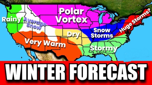
NOAA’s long-lead guidance indicates that temperatures during the core winter months of December–February will likely feature above-normal readings across much of the northern and western United States, consistent with the canonical El Niño teleconnection of a warmer northern tier. Equal chances of near-, above-, or below-normal temperatures are favored over portions of the southern half of the country, where the competing influences of occasional cool fronts and long-term warming trends tend to balance. Alaska is expected to run warmer than average over most of the mainland, although coastal areas influenced by cooler local sea surface temperatures may see more equal chances. The pattern reflects a projected high-pressure tendency over Canada that limits the southward push of polar air, allowing milder Pacific air masses to dominate the northern states. While individual cold outbreaks remain possible, the overall seasonal mean is tilted toward reduced severity of prolonged freezes in the Upper Midwest and Northeast. These temperature signals strengthen as El Niño teleconnections mature through autumn.
National Precipitation and Storm Track Outlook
Precipitation outlooks become increasingly El Niño-like as the season progresses, with elevated chances of above-normal precipitation stretching across the southern United States from California through the Gulf Coast and into the Southeast and Mid-Atlantic. The highest confidence for wetter-than-average conditions lies over the Gulf States and adjacent areas, where a strengthened subtropical jet is expected to deliver frequent storms. In contrast, below-normal precipitation is favored from the Pacific Northwest into the Central Plains and parts of the Great Lakes region, as the primary storm track shifts south of its usual winter position. This displacement can reduce overall snowfall potential across the Northern Plains, Upper Midwest, and Great Lakes even if individual storms produce significant accumulations farther south. Mountainous areas of the southern Rockies and Sierra Nevada may still see heavy snow when colder air is present, while lower elevations in the South face greater flood and severe-weather risks. The evolving precipitation pattern is already evident in early fall guidance and is expected to intensify through the winter months.
US 2026 Winter Weather Forecast for West and Southwest
Across the West, California stands out as one of the regions most likely to experience significant winter impacts. Strong El Niño events historically increase the frequency of atmospheric river events that can deliver heavy rainfall to Southern California and substantial snowfall to the central Sierra Nevada. Flooding risks rise in low-lying areas, while mountain ski resorts may benefit from deeper snowpacks if temperatures remain cold enough at elevation. The Southwest, including parts of Arizona, New Mexico, and the southern Rockies, is also tilted toward above-normal precipitation, which could help alleviate lingering drought concerns in some basins. Farther north, the Pacific Northwest is more likely to see drier and milder conditions overall, with reduced snowfall in the Cascades relative to a typical winter. High-pressure ridging over western Canada and the northern Rockies may further suppress deep cold and frequent storms in the northern tier of the West. Residents and water managers in California and the Southwest should monitor evolving forecasts for potential extremes in rainfall intensity.
US 2026 Winter Weather Forecast for Central and Southern Plains
The Central and Southern Plains are expected to sit near the boundary between the wetter southern storm track and the drier northern regime. Texas and Oklahoma may experience above-normal precipitation at times, particularly when storms track from the southern Rockies or Gulf of Mexico, raising the potential for both beneficial rains and localized flooding. Colder air can occasionally reach these latitudes, creating opportunities for wintry mixed precipitation or even snow farther north in the High Plains. Overall temperatures are more likely to average near or slightly above normal, though sharp cold snaps remain possible. Drought-prone areas could see temporary relief, yet the timing and intensity of precipitation events will determine agricultural and water-supply outcomes. The southern jet stream energy is projected to keep the storm track active enough to produce several notable systems through the heart of winter.
US 2026 Winter Weather Forecast for Midwest, Great Lakes, and Ohio Valley
In the Midwest and Great Lakes region, the combination of milder temperatures and a southward-shifted storm track points toward reduced seasonal snowfall totals relative to average in many locations. High-pressure blocking over Canada is expected to limit the frequency of classic Arctic outbreaks that fuel lake-effect snow bands and widespread accumulating snow events. While individual storms may still deliver measurable snow, especially early or late in the season, the overall snowpack is favored to be lighter across the Upper Midwest and northern Great Lakes. The Ohio Valley may see a mix of rain and snow depending on the exact track of each system, with periods of mild weather interrupting colder intervals. Heating demand could run closer to normal or slightly below in some cities compared with recent colder winters. Local variability will remain high, and residents should still prepare for occasional disruptive winter storms.
US 2026 Winter Weather Forecast for Southeast, Gulf Coast, and Mid-Atlantic
The Southeast and Gulf Coast are among the regions with the strongest signal for above-normal precipitation. Frequent storm systems moving along the southern jet stream can bring heavy rainfall, elevating the risk of flash flooding, river flooding, and periods of severe weather including tornadoes, particularly in Florida and adjacent states. Temperatures are more likely to average near normal, as the occasional cool front is balanced by the broader mild influence of El Niño and long-term warming trends. Freezing rain or light snow becomes more possible if sufficiently cold air is present during precipitation events. The Mid-Atlantic may also experience enhanced precipitation, with a greater chance of mixed precipitation or coastal storms that can produce significant rain or, under colder setups, snow in interior and higher-elevation areas. Emergency managers in these regions are already watching for the potential of more active cool-season weather.
Regional Forecast Highlights: Northeast and New England
The Northeast and New England are projected to lean milder than average overall, with a reduced frequency of prolonged Arctic cold. Snowfall totals are more likely to run near or below normal in many locations because of the combination of warmer temperatures and a storm track that often remains farther south. Coastal areas may see more rain than snow during major precipitation events, while interior and higher-elevation locations retain a better chance of accumulating snow. Periods of significant precipitation are still possible, especially if nor’easters develop along the enhanced southern jet. Early and late winter may offer better opportunities for snowfall than the core months if the pattern evolves. Travelers and municipalities should plan for a mix of rain, mixed precipitation, and occasional snow rather than a consistently deep snow season.
Potential Hazards and Impacts
A strong El Niño increases the odds of several high-impact weather types. Heavy rainfall across the southern tier raises the threat of flash and river flooding, while the same systems can produce severe thunderstorms and tornadoes in the Deep South and Florida during the cool season. Mountain snowstorms in California and the southern Rockies can create travel disruptions and avalanche risks even as lower elevations flood. In the North, reduced snow cover and milder temperatures may ease some winter maintenance burdens but can also affect water supplies that depend on spring snowmelt. Freezing rain becomes a greater concern in transition zones when cold air is present beneath warm, moist flow aloft. Agricultural interests, energy producers, and transportation networks will need to monitor evolving forecasts closely as the pattern locks in through autumn.
Uncertainties and How Forecasts Will Evolve
Seasonal forecasts remain probabilistic and are subject to revision as additional data arrive. The exact peak intensity of El Niño, the behavior of the polar vortex, and the phase of the North Atlantic Oscillation can all modulate the classic El Niño pattern. NOAA will update its official winter outlook in the coming months, typically around mid-month, incorporating the latest model ensembles and observational trends. AccuWeather and other private services plan to release more detailed winter forecasts in early October. Historical analogs of strong El Niño winters provide useful guidance but are never perfect matches. Residents should treat current outlooks as a guide for preparation rather than precise predictions of individual storms, and continue to follow local National Weather Service offices for short-term forecasts as winter approaches.
Preparation Tips for the Coming Season
Homeowners in the southern United States should review drainage systems, clear gutters, and ensure sump pumps are functional given elevated flood risks. Northern residents may still need to service heating systems and stock winter supplies, even if the season runs milder overall. Drivers across the country should prepare for a mix of rain, ice, and snow depending on location, carrying emergency kits and checking vehicle readiness. Ski areas in the Sierra and southern Rockies could see strong seasons, while northern resorts may face more variable conditions. Water managers and farmers should track precipitation trends for both drought relief and excess-moisture concerns. Staying informed through official NOAA and National Weather Service channels remains the best way to adjust plans as the 2026–2027 winter pattern clarifies.